A short visit
to Rajaji National Park – Chilla range
A Golden backed woodpecker inside the TRH Chilla
We were struck up and could not
undertake any short trips due to certain difficulties in my home front. However, we got a short window of about a few
days and I had to plan for a destination that could be reached overnight or
across a day and after visiting the destination for a day, return back the next
day. After much research, I zeroed in on
Chilla range of Rajaji National Park. It
is situated in Haridwar District of Uttarakhand and is about 220 odd kilometres from Delhi and
further lies about 8 Kms. from the Hardwar Railway Station. The distance was doable within about five
hours and in case of any exigency I could rush back at home quickly. Being a reserve forest, it was an ideal
location for us, to be away from the hustle and bustle of city life for some
time. For the trip to fructify, the
foremost requirement was to identify a suitable place to stay at the location
and also to find out if any accommodation was still available. There are only two good boarding &
lodging arrangement within the precincts as well as periphery of the Park
vicinity i.e. the Forest Rest House and the other one is the Tourist Rest House
run by Garhwal Mandal Vikas Nigam Ltd. (GMVN for short). By luck I could source a family room in the
GMVN run facility, as the Forest Rest house was fully booked.
A map showing location of Rajaji National Park, Chilla (sourced from net)
The outer gate of TRH, Chilla
Inside wide-angle view of TRH, Chilla
View of water canal formed by the barrage behind TRH, Chilla
A Cormorant looking for fish in the canal behind TRH, Chilla
We
started in the morning at around 7.30 A.M, which was quite late by our
standards, considering the fact that whenever I visit my summer pad in
Ranikhet, we usually start at around 6.00 A.M sharp.But as the distance was about more than a 100
Kms. less and coupled with the fact that the present drive did not require any
hill driving, we were quite comfortably placed.The road from Delhi to Meerut was excellent, being newly constructed, by
using the bye-pass we were able to make quick progress upto Meerut.Thereafter, the road was again congested and
the journey, time consuming.Around
10.00 A.M we reached Muzzafar Nagar and had our first break for B’fast at
Bikanerwala, which is very conveniently placed, right on the highway, with
ample parking space.The restaurant
offers great food and there is a wide variety to choose from and the public
utilities are well maintained and is a most suitable spot to drop in for a
short break.Having, had our fill we
proceeded further and reached Haridwar after negotiating another bottleneck at
Roorkee.Having reached Haridwar, we
overshot the cut which led to the destination and instead manoeuvred our car
towards the barrage entry and were rightly guided back to take the cut from
road that leads towards Chandi Devi temple and we finally reached Chilla at
around 3.00 P.M.Thereafter, having made
ourselves comfortable in our rooms, we ordered some snacks and really enjoyed
them, the food per se was quite delicious in the GMVN run Tourist Rest
House.Having had our tea and snacks, it
was time to call up Viru Negi to check out about the next day’s safari booking
for visiting Rajaji National Park.Late
in the evening he turned up in his Jeep and after dropping his guests for the
day, we had tete a’ tete and I sought the afternoon safari for the next
day.During the period that I waited for
Viru Negi ji to make an appearance, I strolled along the canal formed due to
barrage across the Ganga River and could spot quite a few birds around the TRH
complex itself and shot photographs using my camera and am sharing with you all
in my blog.
A Buzzard flying by at the birding spot near Chilla
Some Cormorants flying across in the sky avboe
Bahminy Shelduck in Ganga in the birding spot near Chilla
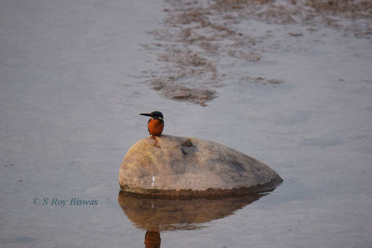
A Common Kingfisher in the birding spot near Chilla
New day morning
while I was strolling with my camera along the side of TRH, another local bird
enthusiast approached me and gave me some information about another birding
spot in the locality and we drove up to the destination and shot a few birds
with my camera, accompanied by my Son and daughter. Thereafter, we returned back to have lunch
around 1.30 P.M and were thereafter, picked up by Viru Negi ji for our
afternoon safari at around 2.30 P.M, since the safari began at 3.00 P.M. The Rajaji National Park is situated along the hills
and foothills of Shiwalik ranges in the Himalayan foothills within the Shivalik
biosphere. Historically speaking, there used to be
three separate wildlife sanctuaries namely – Rajaji Wildlife Sanctuary
established in 1948; Moticur Wildlife Sanctuary established in 1964; and Chilla
Wildlife Sanctuary established in 1977.
In the year 1983 all these three reserves were all combined to create
one body named as the Rajaji National Park and in the year 2015 it received the
status of a Tiger Reserve. It is named
after Sri C Rajagopalachari – the first Governor General of free India. Spread across more than 800 Sq. Km., with
altitude spanning from 330 to 1350 meters, it is a fairly large park that is
adjacent to the holy cities of Hardwar, Rishikesh and Dehradun in Uttarakhand. Chilla Reserve is situated next to the
hydropower plant. So one can see a
branch of Ganga flowing here, with many seasonal rivers merging into it. In fact, the GMVN guest house is located on a
narrow strip of land where one such seasonal stream meets the Ganga.
A Golden backed woodpecker inside Chilla range
Terai like grasslands inside the Chilla range
Huge Sal trees and other trees inside the forest in Chilla range
A Back shouldered Kite inside the Chilla range
A Siberian stonechat inside Chilla range
A male Chital or Spotted deer inside Chilla range
A small portion of the holy River Ganga flows for about 24 km
within the park precincts. Other small seasonal rivers or rivulets join it at
various places within the reserve forest. However, we could only see some dry River beds
across the reserve, through which our jeeps drove through during the
safari. The
area is covered with diverse forest types ranging from semi-evergreen to
deciduous and from mixed broad-leaved to terai like grassland and has been
classified as Indus-Ganges Monsoon Forest type. Lofty strands of Sal dominate
in many parts of this forest range giving it a surreal feeling, as the evenings
set in.
Pug mark of both Elephant and a leopard inside Chilla range
A watch tower inside the Chilla range
A Mountain Hawk Eagle inside the Chilla range
A juvenile Sambar male inside the Chilla range
A Sambar female inside Chilla range
Rajaji
is home to a plethora of avian species, which are found in forested foothills
and in open grassland. The location of
this reserve forest being in a transition zone between temperate western
Himalaya and central Himalaya enhances the species diversity and consequently
the viewing prospects of a large number of birds that inhabit this broad
spectrum. As per the official website, the Rajaji's checklist has about 400
bird species and includes good birds like Greater Scaup, White-naped
Woodpecker, Great Hornbill, Black-bellied Tern, Pallas's Fish Eagle, Northern
Goshawk, Black-necked Stork, Yellow-billed Blue Magpie, Scaly Thrush,
Snowy-browed Flycatcher, Rusty-flanked Tree-creepers, Pale-footed Bush Warbler,
Tytler's Leaf Warbler, Green Avadavat and Reed Bunting. Apart from this, the National park is
best known for is its elephants. I had always heard about herds of elephants
roaming freely in the region that one can come across while driving through the
forest, but it was not to be in our case. In fact, this is the identified North
Western end of Elephant corridor in India. If you travel further North or West
from here, you would not find any wild elephants.
A male Peacock inside Chilla range
A female Red Jungle fowl inside Chilla range
A White breasted Kingfisher inside Chilla range
A Woolly necked Stork inside Chilla range
Sambhar deer - both male & female inside Chilla range
The safari charges are quite
reasonable with a Jeep Safari of two and half hours duration costing around
Rs.3,500/- with guide, but may vary from season to season.As the winters had yet to pass and the
weather was not very clear and being quite cold early in the morning, I
preferred an afternoon safari.The
afternoon safari starts at about 3.00 P.M and ends at about 5.30 P.M and one
can book it in advance or get one at the entry gate itself, if the rush is
less.I, on the other hand, was able to
establish contact with one of the well-known guides operating in the Rajaji
National Park and is quite well acquainted with all the portions of the
park.I had contacted him over phone and
he was courteous enough to arrange for the entire safari for us and his name is
Viru Negi (Mobile No.+91-9917606031).He is a very nice person and anyone interested can contact him directly
on this mobile.The safari itself is
better than that of Corbett in respect of time and distance covered, albeit
there are fewer Tiger sightings in the region.We got to see a lots of deer, birds including Jungle fowls and by the
time as the evening set in, we could hear alarm calls of Langurs and Sambars,
but could not sight any Tiger nor any Elephants to speak of.By the time we were returning back, it had
become literally cold and we were also famished, as the Park authorities do not
allow any packed food items inside the park and rightly so.The photographs shall speak for themselves
about the trip and a short video of the safari inside the park for my viewers –
(All
the blog links provided also contain short duration videos for the destination
as well)
The panorama of Himalayan ranges as seen from Ranikhet
In continuation
of my earlier blogs that was published for promoting tourism in Nainital
region, the present blog starts with the other part of Uttarakhand’s
linguistically identified region i.e. Kumaon.
Kumaon region can further been identified as four distinct regions i.e.
Nainital, Almora, Pithoragarh and Champawat.
The blog of the series highlights Almora and Pithoragarh alongwith
places around it. Here is the video that
covers this region –
Almora
A view from Almora
The famed Jageshwar temple complex
A distant view of Katarmal Sun temple on hill side
Almora is
the headquarters of the biggest district of the State and is a well-known
destination of Uttarakhand, it is situated about 63 Kms. from Nainital.Almora is situated on a ridge at the southern
end of the Kumaon hills at an average elevation of 1861 meters.The famous Almora bazar is saddled across
this ridge that is appears like a saddle with two ends at Eastern and Western
sides known as the Talifat and Salifat respectively.Historically speaking, the Almora town is one
of the oldest in the region that traces back its existence to 1568, as being
established by Raja Kalyan Singh of Chand Dynasty and has been in existence in
the present form since then, but its existence can be traced to pre-Mahabharata
period also.The town also symbolizes
the cultural heritage of the Kumaon and accordingly has hosted various
luminaries like Swami Vivekananda, Rabindranath Tagore etc. and was home to
many other illustrious persons like Sumitra Nandan Pant (Poet), Gobind Ballabh
Pant etc.The town has many places of
historical importance and other distinct identity of Almora is the Katarmal Sun
temple.There is also a very well-known
Shiva temple complex in vicinity of Almora and here are the links to my blogs
about them –
Apart from the above, there
are other destinations that can be visited from Almora and some of them are as
follows –
Binsar
View of Himalayan ranges from Binsar
Binsar was the summer capital
of the Chand rulers and situated about 33 Kms from Almora at an elevation of
2412 meters.In order to conserve the
natural flora and fauna of this region, an area of about 45 sq. kms. was
converted into a Wildlife reserve in 1988.Here is the blog link for the destination –
Sitlakhet
is a lesser known nondescript little destination of Almora district that is
about 35 Kms. from Almora and 20 odd kms. from Ranikhet.It is perched at an altitude of about 1900
meters and is a delight for nature lovers and trekkers.Here is the link to my blog about this
destination –
Early morning view of Himalayan ranges from Ranikhet
Ranikhet or the Queens meadow
is a charming little destination that offers outstanding views of the Himalayan
ranges.It is a well known Cantonment
established by the British in 1869 as headquarters of the famed Kumaon regiment
and at present also acts as the headquarters for the equally famous Naga
regiment.It has a salubrious climate
all through the year and a nature lover’s delight.Perched at an altitude of 1869 meters, it is
an immensely popular summer destination.Here are the links to my blogs about this destination –
The Dwarhat region is a
conglomeration of 116 villages and is situated at a distance of about 73 kms.
from Almora and about 33 kms. from Ranikhet.It houses an old 11th Century old temple complex and is more
well known for the famed ancient temple of Dunagiri situated about 14 Kms. from
Dwarhat and is perched at an altitude of about 2400 meters.Here is the link to my blog about the
destination –
Pithoragarh is the
easternmost district of the Kumaon region and borders Nepal and China
(Tibet).This region is replete with
various glaciers that are ideal trekking destinations for the adventure loving
tourists.Apart from this, there are
several hill stations that offer spectacular views of the Himalayan ranges,
being present within the district precincts.There are several valleys and bugyals that offer moderate treks and
resplendent views of Himalayas as well as rich flora & fauna for the nature
lovers.The most well known destination
in this district is Munsiyari and on our way from Almora, the first destination
that is worth mentioning is Chaukori.
Chaukori –
View of the TRH, KMVN in Chaukori
Chaukori is a small village,
but an amazing destination with the Kumaon Mandal Vikas Nigam offering good
accommodation and views from its property situated here.It is about 115 kms. from Almora via
Bageshwar and one can throw in a night’s stay in Kausani (in Bageshwar
district) while travelling to this destination.The destination offers a splendour of colours during the sunrise and
sunsets over the Himalayan ranges from this destination.It has also some old tea gardens situated
within its precincts.Perched at an
altitude of 2010 meters, this idyllic destinations offers a few nights of
relief to tourists from the plains below during the hot summer months, with a
few temple destinations around it.Here
is link to my blog about the destination –
Situated at a distance of
about 15 kms. from Chaukori is the temple town of Berinag, perched at an
altitude of 1869 meters and is home to the famous and ancient Nag (Snake) temple, which is
reverend by the locals.Here is the link
to the blog about this destination –
Munsiyari
in local dialect means ‘place with snow’ and as the name suggests it is one of
the most resplendent hill stations of Kumaon region.Perched at an altitude of 2298 meters, it
offers spectacular views of the Panchachuli ranges alongwith being an launching
pad for the Milam, Namik and Relam glacier treks in Nanda Devi Biosphere
reserve.It is a must visit destination
for the avid nature lovers.Here is the
link to my blog about the destination –
Pithoragarph township (photo sourced from Widipedia)
It is the district headquarters of the district
that goes by the same name.Perched in a
valley at an altitude of 1541 meters with air connectivity, it is known as the
Soar valley or at times as the little Kashmir.It has historical antecedents and is home to some old temples and a
quaint destination to be enjoyed throughout the year, although air connectivity
remains suspended during the winters.Here is a short blog about the destination –
Note – Although all the
blogs are relatively old, but the geographic locations as well as the
information about the destinations remain unchanged and hence can be referred
to for that purpose.
In continuation
of my earlier blogs that was published for promoting tourism in Garhwal region,
the present blog starts with the other part of Uttarakhand’s linguistically
identified region i.e. Kumaon.Kumaon
region can further been identified as four distinct regions i.e. Nainital,
Almora, Pithoragarh and Champawat.The
first blog of the series will start with Nainital and places around it Here is the video that covers this region –
Nainital
Nainital is
the most well-known destination of Uttarakhand and is also the district
Headquarters that goes by the same name.Nainital is also known as the ‘Lake district of the State’, as this
district has many small and big lakes scattered all around.The entry to Kumaon region is through
Haldwani or Kathgodam, which is the last rail head.From Kathgodam the journey for Kumaon region
commences and the most famous destination in this circuit is Nainital.Nainital, named as the place where the ‘eyes’ (Naina)
of ‘Sati’ fell here and is revered as one of the 64 ‘Shakti Peeths’,
is the most famous destination in the Kumaon region. The lake is about 1.3 kms. long and about 0.5
kms. in breadth, while the northern end of the lake is called the ‘Mallital’
and the southern tip as ‘Tallital’.The lake is situated at an altitude of 1940 meters and is surrounded by
many peaks, some of which tower over 8,000 feet i.e. China Peak.It is a destination enjoyed by tourists, both
during summers and winters equally.Apart
from Nainital, there are other equally enthralling destinations having lakes
around Nainital and easily accessible from Nainital during a day tour and to
name a few (ascending order of distance from Nainital) –
Sattal – This destination as the name depicts, is a
conglomeration of seven lakes and is also perched at around an altitude of 1300
odd meters.This destination is enjoyed
by tourists for boating and is a much sought after destination for ‘Birders’,
as it offers sighting of plethora of birds;
A view of the Sattal lake
Bhimtal - This quaint little township perched at an
elevation of 1370 meters, houses the biggest lake of the region and accordingly
named Bhimtal. It is an enjoyable
destination that offers facilities of boating and fishing;
View of Bhimtal lake
Naukuchiatal – As the name suggests, the lake in this
destination is ‘nine cornered’ one and perched at an elevation of 1220
meters. It is the deepest lake in the
region at is about 175 feet deep and tourists can enjoy boating, angling and
bird watching in the destination.
The Naukuchia lake
Here is the link to my blog
encompassing all these destinations –
Also
known as Pangot, this destination is a sublime one, away from hustle and bustle
of Nainital and a drive of 13 Kms. from the township.Perched at an elevation of 6,510 feet, this
quaint little village destination is a must visit for avid bird watchers, as
about 580 bird species have been identified visiting this area.Here is the link to the blog for the
destination - https://ghummakar-biswas.blogspot.com/2012/09/walking-through-clouds-panghoot-around.html
Mukteshwar
Mukteshwar - the house where Jim Corbett used to stay during summers
This township is about 51 Kms. from
Nainital and perched at an elevation of 2171 meters i.e. about 7500 feet, this
destination is named after the 350 years old Shiva temple situated here.This destination offers fantastic views of
sunrise and sunset alongwith sporting activities like rappelling etc., to add
to the charm of this destination.It is
a must visit destination for nature lovers and those who enjoy the splendour of
the hills.Here is the link to the blog
about this destination -https://ghummakar-biswas.blogspot.com/2011/12/kumaon-mukteshwar-view-of-sitla-from.html
Kainchi Dham
The famed Kainchi dham temple
Kainchi is a beautiful ashram located in secluded mountain of the Kumoan
Hills in Uttarakand. The temple was first inaugurated in June 1964. It is
approximately 38 km from Nainital. Many hundreds of people visit the temples
here every day, during the season. It was some time in 1962 when
Maharajji called for Shri Poornanand of Kainchi village while he himself waited
sitting on parapet wall by the road side near Kainchi. When he came, they
refreshed the memories of their first meeting which they had 20 years back in
1942. They discussed about the place around. Maharajji wanted to see the place
where Sadhu Premi Baba and Sombari Maharaj had lived and performed Yagyas. The
forest was cleared and Maharajji asked for the construction of a Chabootara
(rectangular platform) covering the Yagyashala. Maharajji contacted the then
"conservator of forests" and took possession of the requisite land on
lease. The Hanuman temple is built over the platform mentioned above. His
devotees started coming from different places and a chain of bhandaras,
kirtans, bhajans started. The Pran-Pratishtha of idols of Hanumanji and others
was performed on 15th June in different years. Thus, 15th June is celebrated
every year as Pratishtha Divas Each year, during the famous June 15th
bhandara. The place is of international repute boasting of followers like
Steve Job & Mark Zuckerberg.