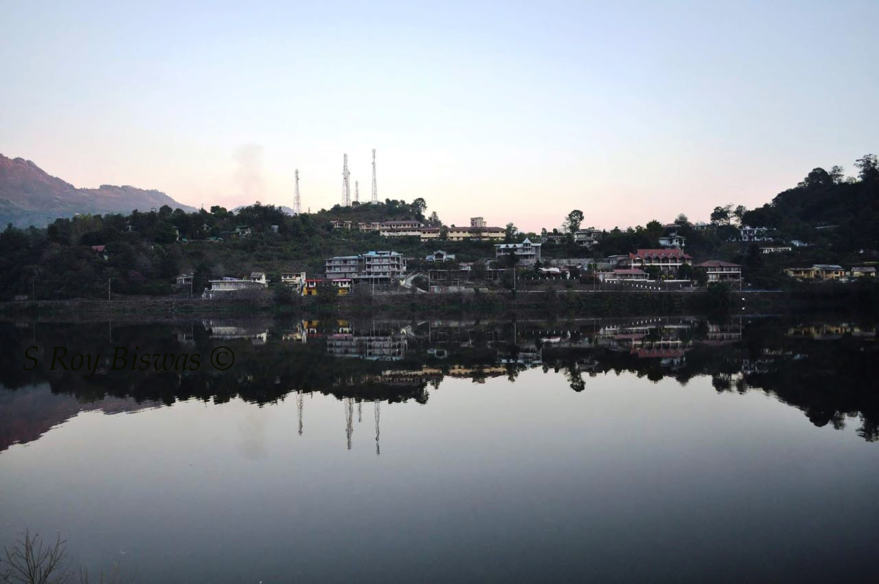
Bhimtal is the biggest lake in the Nainital district of
Uttarakhand. This lake has been in
existence since ancient times, being a gateway to the plains below for people
moving in from present day Pithoragarh and Tibet etc. for trade during historic
times. It was discovered by the British
only in 1841 and developed to some extent by them. Folklore of the region say that the Pandavas
had visited the place and Draupadi was thirsty, so Bhima struck the ground and
water flowed forth in this place that formed a lake and since then the water
continues of replenish the lake perennially, thus, the lake is named after him
as Bhimtal. An ancient Shiva temple,
known as ‘Bhimeshwara Mahadev’ temple is also located in Bhimtal, which as per
folklore is touted to have been built by Bhima and has been standing there
since centuries. The present temple was
renovated in the 17th Century A.D by Kumaon King Baz Bahadur of
Chand dynasty.
Bird's eye view of Bhimtal - all buildings cramping up the place
Panoramic view of Bhimtal lake
As the clouds envelope Bhimtal lake during monsoon
Another view of Bhimtal lake during monsoon
Geographically, Bhimtal is located about 22 Kms. from
Nainital and about 20 Kms. from the last railhead Kathgodam. It is perched at an altitude of 1370 meters
and enjoys a salubrious climate the year round.
Bhimtal is situated at the base
of Karkotaka mountain, named after the famed mythological Snake. At present Bhimtal has become a hub of
housing activity all across this mountain, with several individual and
apartments coming up in the region. The
tourists get to enjoy boat ride in the lake and also angling facility. During the recent past the adventure of para
gliding has also been added in the list of activities that the tourists can
enjoy. The STD Code for Bhimtal is – 05942
and the Pin Code of Bhimtal is – 263136.
Panoramic view of Kosi River meeting Khairna River at Khairna
Having described
Tarikhet in my previous blog, as I reiterate my steps back towards Kathgodam
from my village Badankhet in Tarikhet Block in Ranikhet Tehsil of Almora
District in Uttarakhad in Kumaon region of the State, one passes through the
junction of Ganiadholi, wherefrom the road bifurcates towards Ranikhet and
Tarikhet.Thereafter, as one heads away
from Ranikhet, one comes across villages like Pilkholi, known to the travellers
where one can buy traditional Kumaoni sweets like Choclate (a milk based
product), Bal Mithai and Singhori (remaining ones too be milk based
sweets).Thereafter, across the twenty
three kilometres journey from Tarikhet to Khairna one passes by many other
villages perched by the roadside in the following sequence - Bajol – Bhujan –
Majhera.Thereafter, one crosses the
bridge across Kosi River and turn right towards Kharina and the other road from
here, towards the left hand side, heads
towards Almora.Thus, Khairna (PIN Code
– 263135/STD Code – 05942) is also basically a junction point, wherefrom the
road bifurcates towards Ranikhet and Almora.
Ganiadholi - wherefrom road bifurcates towards Ranikhet & Tarikhet
A panoramic view of villages perched on the road from Ranikhet to Khairna
Khairna is also a
market township that caters to the needs of the villages all around it that are
situated on the road towards Betalghat and other villages of Naintial district
around it.Earlier, the two destinations
of Khairna and thereafter, Garam Pani were distinct and separate, but over the
years, with the spread of the market area along the highway, the distinction
has all but faded.There is a Petrol
pump situated in this quaint village town, being bang on the National Highway
109.Khairna is situated on the
confluence of the Kosi and Khairna Rivers, the first one flowing from Almora
side and the second one from Nainital side.Khairna is thus, placed in the valley perched in between mountains at an
altitude of 913.34 meters i.e. about 2996.51 feet above mean sea level
(MSL).Therefore, during the day time in
summers it is considerably hot and heat is modest during the nights.However, during winters it is quite cold but
not totally unpleasant.
Khairna by night - shot taken from KMVN, Khairna
A Crested Kingfisher in Kosi River - early morning shot
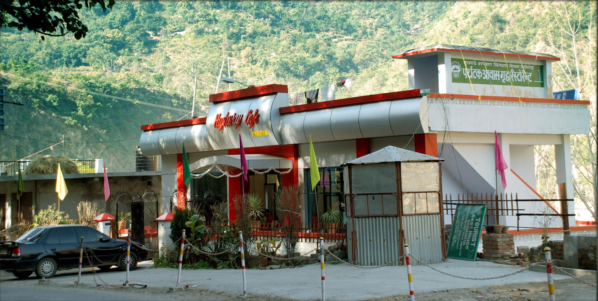
View of TRH at Khairna managed by KMVN - sourced from internet
There are no distinct
travel landmarks in Khairna, but can be used as a transit point while
travelling to distant destinations in the Kumaon region.Although fishing is prohibited, but one can
enjoy feeding the fishes by going down the stairs of the KMVN managed Tourist
Rest House in Khairna, which also offers a restaurant as well as rooms to stay
for the tourists/visitors.The freshly
cooked food in this restaurant has always been my favourite and whenever, I
traverse through this part, especially when travelling by train upto Kathgodam,
I stop here for either lunch or snacks and never had any complaint regarding
the quality of food.Various aquatic
birds can also be spotted in this region, especially early in the mornings and
hence a short stopover for birders is also advisable.So next time you are in Kumaon, remember this
quaint nondescript destination.
(All
the blog links provided also contain short duration videos for the destination
as well)
The panorama of Himalayan ranges as seen from Ranikhet
In continuation
of my earlier blogs that was published for promoting tourism in Nainital
region, the present blog starts with the other part of Uttarakhand’s
linguistically identified region i.e. Kumaon.
Kumaon region can further been identified as four distinct regions i.e.
Nainital, Almora, Pithoragarh and Champawat.
The blog of the series highlights Almora and Pithoragarh alongwith
places around it. Here is the video that
covers this region –
Almora
A view from Almora
The famed Jageshwar temple complex
A distant view of Katarmal Sun temple on hill side
Almora is
the headquarters of the biggest district of the State and is a well-known
destination of Uttarakhand, it is situated about 63 Kms. from Nainital.Almora is situated on a ridge at the southern
end of the Kumaon hills at an average elevation of 1861 meters.The famous Almora bazar is saddled across
this ridge that is appears like a saddle with two ends at Eastern and Western
sides known as the Talifat and Salifat respectively.Historically speaking, the Almora town is one
of the oldest in the region that traces back its existence to 1568, as being
established by Raja Kalyan Singh of Chand Dynasty and has been in existence in
the present form since then, but its existence can be traced to pre-Mahabharata
period also.The town also symbolizes
the cultural heritage of the Kumaon and accordingly has hosted various
luminaries like Swami Vivekananda, Rabindranath Tagore etc. and was home to
many other illustrious persons like Sumitra Nandan Pant (Poet), Gobind Ballabh
Pant etc.The town has many places of
historical importance and other distinct identity of Almora is the Katarmal Sun
temple.There is also a very well-known
Shiva temple complex in vicinity of Almora and here are the links to my blogs
about them –
Apart from the above, there
are other destinations that can be visited from Almora and some of them are as
follows –
Binsar
View of Himalayan ranges from Binsar
Binsar was the summer capital
of the Chand rulers and situated about 33 Kms from Almora at an elevation of
2412 meters.In order to conserve the
natural flora and fauna of this region, an area of about 45 sq. kms. was
converted into a Wildlife reserve in 1988.Here is the blog link for the destination –
Sitlakhet
is a lesser known nondescript little destination of Almora district that is
about 35 Kms. from Almora and 20 odd kms. from Ranikhet.It is perched at an altitude of about 1900
meters and is a delight for nature lovers and trekkers.Here is the link to my blog about this
destination –
Early morning view of Himalayan ranges from Ranikhet
Ranikhet or the Queens meadow
is a charming little destination that offers outstanding views of the Himalayan
ranges.It is a well known Cantonment
established by the British in 1869 as headquarters of the famed Kumaon regiment
and at present also acts as the headquarters for the equally famous Naga
regiment.It has a salubrious climate
all through the year and a nature lover’s delight.Perched at an altitude of 1869 meters, it is
an immensely popular summer destination.Here are the links to my blogs about this destination –
The Dwarhat region is a
conglomeration of 116 villages and is situated at a distance of about 73 kms.
from Almora and about 33 kms. from Ranikhet.It houses an old 11th Century old temple complex and is more
well known for the famed ancient temple of Dunagiri situated about 14 Kms. from
Dwarhat and is perched at an altitude of about 2400 meters.Here is the link to my blog about the
destination –
Pithoragarh is the
easternmost district of the Kumaon region and borders Nepal and China
(Tibet).This region is replete with
various glaciers that are ideal trekking destinations for the adventure loving
tourists.Apart from this, there are
several hill stations that offer spectacular views of the Himalayan ranges,
being present within the district precincts.There are several valleys and bugyals that offer moderate treks and
resplendent views of Himalayas as well as rich flora & fauna for the nature
lovers.The most well known destination
in this district is Munsiyari and on our way from Almora, the first destination
that is worth mentioning is Chaukori.
Chaukori –
View of the TRH, KMVN in Chaukori
Chaukori is a small village,
but an amazing destination with the Kumaon Mandal Vikas Nigam offering good
accommodation and views from its property situated here.It is about 115 kms. from Almora via
Bageshwar and one can throw in a night’s stay in Kausani (in Bageshwar
district) while travelling to this destination.The destination offers a splendour of colours during the sunrise and
sunsets over the Himalayan ranges from this destination.It has also some old tea gardens situated
within its precincts.Perched at an
altitude of 2010 meters, this idyllic destinations offers a few nights of
relief to tourists from the plains below during the hot summer months, with a
few temple destinations around it.Here
is link to my blog about the destination –
Situated at a distance of
about 15 kms. from Chaukori is the temple town of Berinag, perched at an
altitude of 1869 meters and is home to the famous and ancient Nag (Snake) temple, which is
reverend by the locals.Here is the link
to the blog about this destination –
Munsiyari
in local dialect means ‘place with snow’ and as the name suggests it is one of
the most resplendent hill stations of Kumaon region.Perched at an altitude of 2298 meters, it
offers spectacular views of the Panchachuli ranges alongwith being an launching
pad for the Milam, Namik and Relam glacier treks in Nanda Devi Biosphere
reserve.It is a must visit destination
for the avid nature lovers.Here is the
link to my blog about the destination –
Pithoragarph township (photo sourced from Widipedia)
It is the district headquarters of the district
that goes by the same name.Perched in a
valley at an altitude of 1541 meters with air connectivity, it is known as the
Soar valley or at times as the little Kashmir.It has historical antecedents and is home to some old temples and a
quaint destination to be enjoyed throughout the year, although air connectivity
remains suspended during the winters.Here is a short blog about the destination –
Note – Although all the
blogs are relatively old, but the geographic locations as well as the
information about the destinations remain unchanged and hence can be referred
to for that purpose.
In continuation
of my earlier blogs that was published for promoting tourism in Garhwal region,
the present blog starts with the other part of Uttarakhand’s linguistically
identified region i.e. Kumaon.Kumaon
region can further been identified as four distinct regions i.e. Nainital,
Almora, Pithoragarh and Champawat.The
first blog of the series will start with Nainital and places around it Here is the video that covers this region –
Nainital
Nainital is
the most well-known destination of Uttarakhand and is also the district
Headquarters that goes by the same name.Nainital is also known as the ‘Lake district of the State’, as this
district has many small and big lakes scattered all around.The entry to Kumaon region is through
Haldwani or Kathgodam, which is the last rail head.From Kathgodam the journey for Kumaon region
commences and the most famous destination in this circuit is Nainital.Nainital, named as the place where the ‘eyes’ (Naina)
of ‘Sati’ fell here and is revered as one of the 64 ‘Shakti Peeths’,
is the most famous destination in the Kumaon region. The lake is about 1.3 kms. long and about 0.5
kms. in breadth, while the northern end of the lake is called the ‘Mallital’
and the southern tip as ‘Tallital’.The lake is situated at an altitude of 1940 meters and is surrounded by
many peaks, some of which tower over 8,000 feet i.e. China Peak.It is a destination enjoyed by tourists, both
during summers and winters equally.Apart
from Nainital, there are other equally enthralling destinations having lakes
around Nainital and easily accessible from Nainital during a day tour and to
name a few (ascending order of distance from Nainital) –
Sattal – This destination as the name depicts, is a
conglomeration of seven lakes and is also perched at around an altitude of 1300
odd meters.This destination is enjoyed
by tourists for boating and is a much sought after destination for ‘Birders’,
as it offers sighting of plethora of birds;
A view of the Sattal lake
Bhimtal - This quaint little township perched at an
elevation of 1370 meters, houses the biggest lake of the region and accordingly
named Bhimtal. It is an enjoyable
destination that offers facilities of boating and fishing;
View of Bhimtal lake
Naukuchiatal – As the name suggests, the lake in this
destination is ‘nine cornered’ one and perched at an elevation of 1220
meters. It is the deepest lake in the
region at is about 175 feet deep and tourists can enjoy boating, angling and
bird watching in the destination.
The Naukuchia lake
Here is the link to my blog
encompassing all these destinations –
Also
known as Pangot, this destination is a sublime one, away from hustle and bustle
of Nainital and a drive of 13 Kms. from the township.Perched at an elevation of 6,510 feet, this
quaint little village destination is a must visit for avid bird watchers, as
about 580 bird species have been identified visiting this area.Here is the link to the blog for the
destination - https://ghummakar-biswas.blogspot.com/2012/09/walking-through-clouds-panghoot-around.html
Mukteshwar
Mukteshwar - the house where Jim Corbett used to stay during summers
This township is about 51 Kms. from
Nainital and perched at an elevation of 2171 meters i.e. about 7500 feet, this
destination is named after the 350 years old Shiva temple situated here.This destination offers fantastic views of
sunrise and sunset alongwith sporting activities like rappelling etc., to add
to the charm of this destination.It is
a must visit destination for nature lovers and those who enjoy the splendour of
the hills.Here is the link to the blog
about this destination -https://ghummakar-biswas.blogspot.com/2011/12/kumaon-mukteshwar-view-of-sitla-from.html
Kainchi Dham
The famed Kainchi dham temple
Kainchi is a beautiful ashram located in secluded mountain of the Kumoan
Hills in Uttarakand. The temple was first inaugurated in June 1964. It is
approximately 38 km from Nainital. Many hundreds of people visit the temples
here every day, during the season. It was some time in 1962 when
Maharajji called for Shri Poornanand of Kainchi village while he himself waited
sitting on parapet wall by the road side near Kainchi. When he came, they
refreshed the memories of their first meeting which they had 20 years back in
1942. They discussed about the place around. Maharajji wanted to see the place
where Sadhu Premi Baba and Sombari Maharaj had lived and performed Yagyas. The
forest was cleared and Maharajji asked for the construction of a Chabootara
(rectangular platform) covering the Yagyashala. Maharajji contacted the then
"conservator of forests" and took possession of the requisite land on
lease. The Hanuman temple is built over the platform mentioned above. His
devotees started coming from different places and a chain of bhandaras,
kirtans, bhajans started. The Pran-Pratishtha of idols of Hanumanji and others
was performed on 15th June in different years. Thus, 15th June is celebrated
every year as Pratishtha Divas Each year, during the famous June 15th
bhandara. The place is of international repute boasting of followers like
Steve Job & Mark Zuckerberg.
Monsoons in
Kumaon – a pictorial display of the mood
As the monsoon clouds drift across the valleys and the mountains
I have had the privilege of growing up in the
hills, having been born and brought up there and also having had my education
up to the middle level, in one of the pristine hill stations of Himachal Pradesh.The hills are a place where one can
experience all the four full seasons, along with the two transitional seasons
of Spring & Autumn, of the natural cycle of seasons.Having now spent a better half of my life in
the plains of Delhi, I can clearly distinguish the difference between the
nature’s glories that spreads its splendour in the hills, as compared to some
drab seasons of Delhi.In the hills, one
can distinguish the seasons distinctly.Starting with Spring, which heralds in after the harsh winters, there is
a nip in the air, but also a distinct feel good factor, as the day temperatures
get steady and pleasant, accompanied by the same, with most of the stone fruit
bearing trees being in full bloom, with flowers of different shades and hues covering
the entire trees and creating an aura of pleasure and happiness all
around.After the gaiety Spring, comes
in the summers that ushers in a feeling of gay abandon.Gone are the heavy woollen clothing and as the
days gete hotter and longer, but bearable and nights are short and sweet. After summers move in the monsoon season or
the rainy season and as the clouds move in, one can experience the intensity of
the rains, which is such that torrents flow through the roads, as if some
seasonal rivulet has sprung forth. This
abundance of water paints forth all the hills in all green and it is one of the
spectacular visual experiences that one can have amongst the four seasons, other
than the winters that is also truly spectacular. Although not a favourite season for the
tourists and thus, only those who stay in the hills enjoy its beauty.The present narration is a pictorial
depiction of the spectacular scenery that unfolds in the hills during monsoons
–
As the rain clouds loom over Ranikhet
The clouds stretch from the plains to the hills - view of Kosi River along Corbett
Tufts of clouds lay scattered across the Ranikhet valley
Clouds drifting in the Nainital valley
Cloud cover all across - view from Bhatrochkhan
A panoramic view of the cloud filled valleys on Naintial
View of the river valley near Garampani in Naintial district
Cloud cover has just lifted - Nainital hills from Bhimtal road
A tuft of cloud suspended mid air - Nainital hills from Bhimtal road
Just after a fresh bout of rain, as the clouds part - view of Ranikhet hills from Timila village
As the clouds envelope - view of Nainital hills from road to Khairna
As the veil of clouds part, some village homes become visible again - shot from Timila village
After fresh shower of rain everything around is dripping with pure water
After a fresh bout of rains, even the grass collect some water
As the monsoon clouds loom large - shot on way to Almora
Just after a bout of rain, the cloud cover clears over Almora
How green is my valley - monsoon green - view from Bhowali village
As the rain clouds drift in - view from Timila village of Teh.Ranikhet
Panoramic view of the rain clouds drifting - view from Timila village of Teh.Ranikhet
As the rain clouds envelopes the valleys - view from Timila village of Teh.Ranikhet
As the clouds hug the hill sides - - view from Timila village of Teh.Ranikhet
Rain clouds nestled in the hills & valleys - - view from Timila village of Teh.Ranikhet
Another view of the rain clouds enveloping the valleys - - view from Timila village of Teh.Ranikhet
Rain drops like diamonds scattered on leaves after rain
As the clouds descend upon the Bhimtal lake
I will follow up this blog with similar
pictorial depictions of the other seasons in the hills, in my ensuing blogs, to
bring out the distinctiveness of the six seasons that one experiences in the
hills.