Andaman & Nicobar
– the Enchanting Coral Islands of India
(General Information)
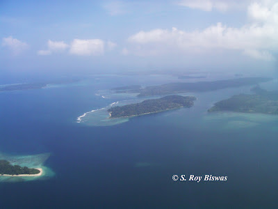
Aerial view of Andaman Islands
Geographically Andaman and Nicobar
Islands appears to be a north-south arc, situated between the 16° and 14° latitude,
and 92° and 94° East longitude in the Bay of Bengal . These Islands are part of land mass of
South-east Asia, including Malaysia ,
North-east India, Burma , Thailand and Indonesia Nicobar
Islands cover an area of 8249
square kilometers. The area of Andaman and Nicobar
Islands comprises
of the islands stretching from nearest the Indian land mass i.e. North Andaman,
followed by Middle Andaman, South Andaman, Little Andaman and farthest is Car
Nicobar. Andaman and Nicobar contain
about 3000 islands, including islets and rocks in the archipelago. The biggest island of the region is the Middle
Andaman Islands (Andaman group) and the smallest is Ross Island Saddle
Peak (Andaman Islands) is 732 meters,
which is situated in Diglipur region of South Andaman and Mount
Thullier (Nicobar
Islands ) is 642 meters. The
Ritchie Archipelago and Labyrinth Islands are the two important groups of islets in
Andaman and Nicobar Islands and these two groups of Islands
is bisected by the 10 Degree channel.
The history
at Andaman and Nicobar Islands indicate that Marco Polo was among the
first travelers from the West to reach this conglomeration of Islands
and had described it as being inhabited by vicious tribes. Mythologically,
these islands were known as Handuman to the Malays and presumably the name is
derived from Lord Hanuman, as he is known in Malayan dialect. These islands were also stated to be the base
for Kanhoji Angre, a Maratha admiral during the early 18th century. However, sovereignty of Kanhoji Angre ended
when he was defeated by the British and Portuguese naval forces. The British briefly occupied these Islands in 1789, but they abandoned the same in
1796. However, the British resumed
control over the island in the 19th century and established Andaman and Nicobar
as a penal colony, which was named 'Kalapani' and housed the infamous Cellular
Jail. Initially the British East India
Company sent hardened criminals to this region, but after the revolt of 1857 it
got constructed the Cellular Jail and started incarcerating the political
prisoners too, this practice only ended with the advent of India gaining
independence from British subjugation.
These Islands were also briefly held by
the Japanese occupation forces during the Second World War, but the treatment
of the prisoners was far from satisfactory.
During this period Netaji Subhash Chandra Bose had paid visit to these
islands. At present these islands are centrally
administered as a Union Territory of India.
As
on date these islands are one of the pristine nature’s treasure troves hosting
an array of islands with tropical rain forests, a spectacular & unique
fauna & flora. These islands offer a
plethora of beaches and with the development over the decades, it now offers
many more attractions some of which are listed as follows –
Beaches:
Corbyn's Cove and Chirya Tapu (Port Blair), Harminder
Bay Beach
(Hut Bay
– Car Nicobar), Ramnagar Beach , Radhanagar
Beach (Havlock), Karmatang Beach
Islands: Red
Skin Island ,
Cinque Island ,
Havelock Island ,
Ross Island ,
Jolly Buoy, Barren
Island
Picnic Spots &
Natural caves etc. :
Corbyn's Cove Tourism Complex, Mount
Harriet
Monument: Cellular Jail, Ross
Island , Viper Island
Museums: Anthropological Museum, National
Memorial, Fisheries Museum , Naval Marine Museum
For
more details log on to –
http://as.and.nic.in/TourismAND/TCorner/TouristSpotNew.htm. The Andaman group of Islands
are now administratively divided into three districts i.e. the South Andaman
(Port Blair & around), Middle Andaman (stretching from Baratang to Rangat)
and North Andaman (stretching from Mayabunder to Diglipur).
Map of Andaman Group of Islands
To visit the Andaman & Nicobar
Islands, one can either fly to this destination from Kolkata, Chennai &
Delhi and flights are catered by Air India Islands by the sea route. The details of sea route are available at –
One can plan his/her trip as per the
number of days he has to cover the region.
In case it is less than a week, one can visit the regions around Port
Blair and include a visit to Havlock
Islands
Map of Nicobar group of Islands
©
S. Roy Biswas – All rights reserved


